Schemes to help reduce flooding
Across Nottinghamshire, a number of flood risk management and flood alleviation schemes are in progress to protect communities from flooding.
These schemes are being delivered alongside partner agencies including:
- The Environment Agency - who manage flooding from generally larger rivers (known as Main Rivers, such as the River Trent)
- Internal Drainage Boards managing low lying areas
- District, Borough, Parish and Town Councils
- Infrastructure/ utility providers - Including Severn Trent Water and the Highways Agency.
Details of ongoing schemes can be found below.
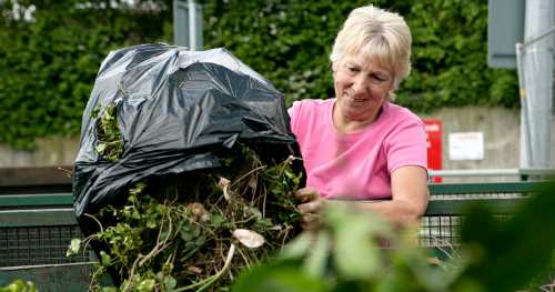
The Community Flood Signage Scheme (CFSS) allows trained members of the community to close roads during times of flooding. The scheme promotes road safety, but also aims to stop vehicles creating bow waves which can cause further damage to property and distress to residents. The scheme is led by Nottinghamshire County Council and currently has over 550 Flood Signage Wardens active in over 40 areas across Nottinghamshire.
How you can help your community during a flood
By volunteering as a Flood Signage Warden, you can:
- prevent vehicles driving through flood water
- safely close roads susceptible to flooding, preventing potentially devastating accidents
- mitigate damage to property
- help your community be more flood resilient
- work with likeminded people to protect the most vulnerable members of your community.
Do I need any special skills?
To become a volunteer Flood Signage Warden you don’t need any previous experience or a huge amount of commitment. You only need to attend an initial one-day training session and a refresher course every three years. This will cover water safety, risk control, road safety and sign set up. When flooding occurs, there may be some unsociable hours of working and you will be required to move road closure signs.
How do I get involved?
If you would like to become a Flood Signage Warden please email flood.team@nottscc.gov.uk to express your interest. As a Flood Signage Warden you will work directly with the Flood Risk Management team at Nottinghamshire County Council and will receive a quarterly newsletter to keep you up to date on the scheme.
Download our Community Flood Signage Scheme (CFSS) flyer [PDF]
Meet our Colwick volunteers
Russell Whiting
Abby Booker
Nik Alexander
Potwell Dyke scheme – August 2025
We have paused the proposed Potwell Dyke scheme in Southwell due to the potential impact on a significant archaeological monument.
The proposed reinforced earth bund which was due to be part of the scheme was found to need to increase in both height and length by 60 metres to be fully effective.
A scheduled ancient monument of significance in Nottinghamshire could be impacted if the bund was to increase in size, and so the county council will now seek further advice from Historic England to understand whether the revised design is likely to gain a new planning consent.
Other impacts of the new design would include the closure of a popular local footpath.
The Potwell scheme is one of a number of flooding measures which make up the Southwell Flood Alleviation Scheme and we will continue to work closely with local partners to explore alternatives to the scheme if it cannot go ahead in the revised form.
If you have a question about the scheme, you can contact: flood.team@nottscc.gov.uk
We will use any questions we receive to draft some frequently asked questions which will be published on our website in the coming weeks.
A project to protect 86 properties from flooding along the Titchfield Park Brook catchment has been allocated £912k of Flood Defence Grant in Aid and Local Levy funding for delivery in 20/21 with support from NCC capital.
The business case was approved in August 2019 and is progressing through detailed design stages. The project has three discreet elements and will delivered utilising expertise available from Ashfield District Council (as landowners of Titchfield Park) and Via East Midland Ltd. Property Flood Resilience measures will be delivered using the Environment Agency’s National Framework. Project completion is expected March 2021.
In February this year, Thoresby Dale in Hucknall experienced significant flooding of the public highway.
A joint response by Severn Trent Water, NCC and Via identified the cause of the flooding to be a significant blockage of the flood alleviation system downstream of Thoresby Dale. Once the blockage had been removed the system operated as designed. Whilst the flooding to the highway was significant there was no internal flooding. It should be noted that there has been no reported flooding since completion of the Flood Alleviation project other than this occasion.
Via are currently looking at ways of reducing the risk and consequences of future blockage related issues.
The Environment Agency are continuing to develop the outline business case for a flood alleviation scheme to protect Lowdham with a view to submitting their business case in August 2020.
Officers from the Flood Risk Management Team are liaising with the Project Team at the Environment Agency and the Lowdham Flood Action Group to help support progress of both the project a community resilience where necessary.
In July, DEFRA announced an additional £5m contribution to this project to help secure its deliverability. Working in Partnership with Severn Trent Water, we have helped deliver improvements to the management of surface water on the Southwell Road that will reduce the risk of flooding to a number of homes. These improvements were delivered by Severn Trent Water on our behalf whilst they were on site working on their sewerage system.
Further improvements are planned within the Old Tannery Drive estate and these will be completed once Covid 19 restrictions allow. This piece of work involves working in private gardens and as such it is harder to comply with working restrictions at the moment. These improvements are being funded by NCC Capital and a contribution from Via.
The county council is implementing Natural Flood Management (NFM) measures to reduce flood risk and benefit the environment. NFM works by using natural processes to manage water flow, helping to absorb and slow down water in upper catchments, which reduces flood peaks downstream. This approach includes installing features like leaky barriers, ponds and earth bunds to manage water flow and enhance the environment. Restoring rivers, creating wetlands and planting trees not only help to store water but also improve habitats, trap sediment and enhance water quality.
NFM Measures
Leaky Barriers
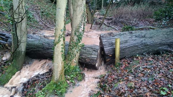
Leaky barriers are wooden structures installed in watercourses to create roughness and slow water flow downstream, while allowing low flows to pass through. These barriers mimic natural processes and provide significant benefits for fish and invertebrate species.
Bunds
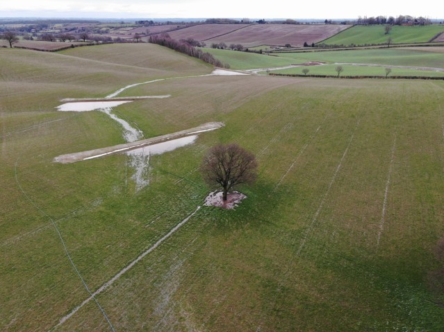
Bunds are compacted earth structures that capture overland water flow and release it slowly through an outlet pipe. These structures not only manage water flow but also help capture sediment, improving downstream water quality.
Ponds and wetlands
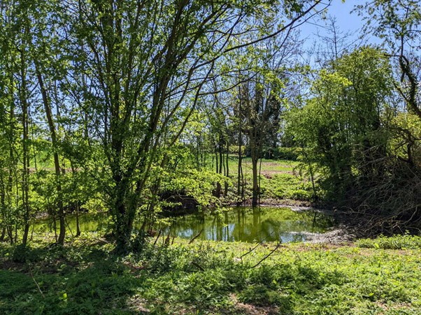
Creating ponds and wetlands helps to store water during high flows and provides vital habitats for many species. They can be installed into the floodplain areas or directly connected to the watercourse itself. Ponds and wetlands can also work to filter out pollutants and improve water quality.
River restoration
Restoring rivers to their natural state is hugely beneficial for flood risk management as it restores their natural functions such as floodplain water storage, meandering channels and waterflow management. River restoration also improves habitats and the local environment.
Tree planting
Planting trees in the catchment improves soil infiltration, allowing soil to act like a sponge during rainfall. Trees create larger soil pores with their root systems, enhancing water storage and providing habitats for many species.
Natural Flood Management schemes
Schemes being scoped out (funding not yet secured)
- Cropwell Butler
- Trowell
Schemes in progress
- Gotham
Working with Trent Rivers Trust, the £40,000 project, funded by the county council and Environment Agency Local Levy, aims to reduce flood risk and enhance the environment. Key features include 60 leaky barriers made of wooden logs to imitate natural dams, two-stage channels for increased storage capacity and earth bunds to control downstream water levels and encourage wildlife habitats. Construction began in March 2025.
Completed schemes
- Woodborough
The £220,000 project, led by Nottinghamshire County Council with support from the Trent Rivers Trust, Environment Agency, and Woodborough Flood Action Group, involved creating earth bunds and attenuation ponds to reduce downstream flooding and encourage wildlife habitats. The project included restoring a stretch of Woodborough Beck and installing leaky barriers to mimic natural dams. The second phase reopened a covered watercourse section, reshaped the river channel, and added more earth bunds to further reduce flood risk. - Costock
The £25,000 project in Costock involved constructing swales, ponds, and earth bunds to manage overland water flow during intense rainfall. These measures help reduce the peak water volume reaching downstream drainage assets, easing pressure and lowering flood risk for the village. - Burton Joyce
Funded and led by Nottinghamshire County Council, the £50,000 project aimed to reduce flood risk from the Crock Dumble through installing leaky barriers, creating wetlands, planting trees and restoring historic ponds. Successful delivery in 2024 with upper catchment landowners' cooperation led to significant flood risk benefits. - Clarborough
Delivered in 2021, the Clarborough project involved installing over 50 features, including leaky barriers, ponds, bunds, and river restoration measures. Close collaboration with Clarborough Parish Council ensured effective targeting of overland water flow paths to reduce flood risk.